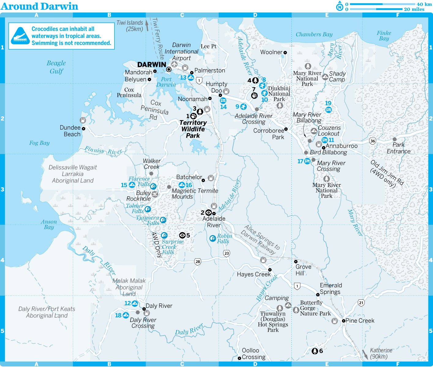
Around Darwin
Mandorah
Mandorah is a low-key, relaxed residential beach suburb looking out across the harbour to Darwin. It sits on the tip of Cox Peninsula, 128km by road from Darwin but only 6km across the harbour by regular ferry. The main reason to visit is for the ferry ride across the harbour and to throw in a fishing line off the jetty here. The nearby Wagait Aboriginal community numbers around 400 residents. Sadly, the Mandorah Beach Hotel has now closed.
The Mandorah Ferry ( GOOGLE MAP ; www.sealinknt.com.au; adult/child return $25/12.50) operates about a dozen daily services (adult/child return $25/12.50), with the first departure from the Cullen Bay Marina in Darwin at 5.45am and the last at 11pm (midnight on Friday and Saturday). The last ferry from Mandorah is at 11.20pm (12.20am Friday and Saturday). Bookings not required.
Around Darwin
1Top Sights
1Sights
2Activities, Courses & Tours
4Sleeping
Tiwi Islands
The Tiwi Islands − Bathurst Island and Melville Island − lie about 80km north of Darwin, and are home to the Tiwi Aboriginal people. The Tiwis ('We People') have a distinct culture and today are well known for producing vibrant art and the occasional champion Aussie Rules football player.
Tourism is restricted on the islands and for most tourists the only way to visit is on one of the daily organised tours from Darwin.
The Tiwis' island homes kept them fairly isolated from mainland developments until the 20th century, and their culture has retained several unique features. Perhaps the best known are the pukumani (burial poles), carved and painted with symbolic and mythological figures, which are erected around graves. More recently the Tiwis have turned their hand to art for sale: carving, painting, textile screen printing, batik and pottery using traditional designs and motifs. The Bima Wear textile factory was set up in 1969 to employ Tiwi women, and today makes many bright fabrics in distinctive designs.
The main settlement on the islands is Nguiu in the southeast of Bathurst Island, which was founded in 1911 as a Catholic mission. On Melville Island the settlements are Pirlangimpi and Milikapiti.
Most of the 2700 Tiwi Islanders live on Bathurst Island (there are about 900 people on Melville Island). Most follow a mainly nontraditional lifestyle, but they still hunt dugong and gather turtle eggs, and hunting and gathering usually supplements the mainland diet a couple of times a week. Tiwis also go back to their traditional lands on Melville Island for a few weeks each year to teach and to learn traditional culture. Descendants of the Japanese pearl divers who regularly visited here early last century also live on Melville Island.
Aussie Rules football is a passion among the islanders and one of the biggest events of the year (and the only time it's possible to visit without a permit or on a tour) is the Tiwi football grand-final day in late March. Huge numbers of people come across from the mainland for the event − book your tour/ferry well in advance.
TTours
There's no public transport on the islands, so the best way to see them is on a tour. You can catch the Tiwi Ferry over to Nguiu and have a look around the town without taking a tour or buying a permit, but if you want to explore further you'll need a permit from the Tiwi Land Council.
Tiwi Tours Aboriginal Cultural ExperienceCULTURAL
(![]() %1300 228
546;
www.aatkings.com/tours/tiwi-tours-aboriginal-cultural-experience)
%1300 228
546;
www.aatkings.com/tours/tiwi-tours-aboriginal-cultural-experience)
Runs fascinating day trips to the Tiwis, although interaction with the local community tends to be limited to your guides and the local workshops and showrooms. The tour is available by ferry (adult/child $250/125, two and a half hours each way Thursday and Friday) or air (adult/child $275/138, 20 minutes each way, Monday to Wednesday)
The tour includes permit, welcome ceremony, craft workshops, and visits to the early Catholic-mission buildings, the Patakijiyali Museum and a pukumani burial site.
Tiwi by DesignCULTURAL
(
MAP
GOOGLE MAP ; ![]() %1300 130
679; www.sealinknt.com.au;
adult $319)
%1300 130
679; www.sealinknt.com.au;
adult $319)
Leaving from Cullen Bay ferry terminal at 7.30am on Thursday and Friday, this tour includes permits, lunch and a welcome ceremony, as well as visits to a local museum, church and art workshop, where you get to create your own design. It's run by Sealink, the ferry operator.
Ferry only prices to get to the island are adult/child $80/40.
Arnhem Highway
The Arnhem Hwy (Rte 36) branches off towards
Kakadu 34km southeast of Darwin. About 10km along the road, in the
small agricultural hub of Humpty Doo, the self-proclaimed 'world
famous' Humpty Doo Hotel (
MAP
GOOGLE MAP ; ![]() %08-8988
1372; www.humptydoohotel.net;
Arnhem Hwy; d/cabins
$130/150;
%08-8988
1372; www.humptydoohotel.net;
Arnhem Hwy; d/cabins
$130/150; ![]() a
a![]() s) is a
brawling kinda roadhouse, serving big meals (mains $20 to $30,
lunch and dinner). There are unremarkable motel rooms and cabins
out the back.
s) is a
brawling kinda roadhouse, serving big meals (mains $20 to $30,
lunch and dinner). There are unremarkable motel rooms and cabins
out the back.
About 15km beyond Humpty Doo is the turn-off to the fecund green carpet of Fogg Dam Conservation Reserve ( MAP GOOGLE MAP ; www.foggdamfriends.org). Bring your binoculars − there are ludicrous numbers of waterbirds living here. The dam walls are closed to walkers (crocs), but there are a couple of nature walks (2.2km and 3.6km) through the forest and woodlands. Bird numbers are highest between December and July.
Three kilometres past the Fogg Dam turnoff is the dashing-looking Window on the Wetlands Visitor Centre, full of displays (static and interactive) explaining the wetland ecosystem, as well as the history of the local Limilgnan-Wulna Aboriginal people. There are great views over the Adelaide River floodplain from the observation deck, and binoculars for studying the waterbirds on Lake Beatrice.
A further 8km beyond the Window on the Wetlands Visitor Centre is Adelaide River Crossing. It's from the murky waters of this river that large crocs are tempted to jump for camera-wielding tourists.
JUMPING CROCS
Few people seem to be able to resist the sight of a 3m-long saltwater crocodile launching itself out of the water towards a hunk of meat. Like a well-trained circus act, these wild crocs know where to get a free feed − and down on the Adelaide River, a croc-jumping show is guaranteed.
Jumping out of the water to grab prey is actually natural behaviour for crocs, usually to take surprised birds or animals from overhanging branches. They use their powerful tails to propel themselves up from a stationary start just below the surface, from where they can see their prey.
There are three operators at different locations along the Adelaide River: Adelaide River Cruises; Adelaide River Queen; and Spectacular Jumping Crocodile Cruise. The modus operandi is pretty similar − a crew member (or nervous tourist) holds one end of a long stick that has a couple of metres of string attached to the other end. Tied to the end of the string is a pork chop − not exactly bush tucker, but the crocs love it. The whole thing is contrived, but it's still an amazing sight. And if you are lucky you will get to see one of the old denizens measuring more than 5m. These old fellas aren't as spritely as their children, but they are a truly awesome sight.
Adelaide River CruisesWILDLIFE CRUISES
(
MAP
GOOGLE MAP ; ![]() %08-8983
3224; www.adelaiderivercruises.com.au;
tours adult/child
$35/20;
%08-8983
3224; www.adelaiderivercruises.com.au;
tours adult/child
$35/20; ![]() h9am, 11am,
1pm & 3pm May-Oct)
h9am, 11am,
1pm & 3pm May-Oct)
See the jumping crocodiles on a private stretch of river past the Fogg Dam turn-off. Also runs small-group full-day wildlife cruises.
Adelaide River QueenWILDLIFE CRUISES
(
MAP
GOOGLE MAP ; ![]() %08-8988
8144; www.jumpingcrocodilecruises.com.au;
tours adult/child
$35/25;
%08-8988
8144; www.jumpingcrocodilecruises.com.au;
tours adult/child
$35/25; ![]() h9am, 11am,
1pm & 3pm Mar-Oct, for times Nov-Feb see
website)
h9am, 11am,
1pm & 3pm Mar-Oct, for times Nov-Feb see
website)
Well-established jumping-crocodile operator on the highway just before Adelaide River Crossing.
Spectacular Jumping Crocodile CruiseWILDLIFE TOURS
(
MAP
GOOGLE MAP ; ![]() %08-8978
9077; www.jumpingcrocodile.com.au;
tours adult/child
$35/20;
%08-8978
9077; www.jumpingcrocodile.com.au;
tours adult/child
$35/20; ![]() h9am, 11am,
1pm & 3pm)
h9am, 11am,
1pm & 3pm)
Along the Window on the Wetlands (
MAP
GOOGLE MAP ;
www.nretas.nt.gov.au/national-parks-and-reserves/parks/windowwetlands;
Arnhem Hwy; ![]() h8am-5.30pm) access road, this outfit runs one-hour
tours. Ask about trips ex-Darwin.
h8am-5.30pm) access road, this outfit runs one-hour
tours. Ask about trips ex-Darwin.
Mary River Region
Beyond the Adelaide River crossing, the Arnhem Hwy passes through the Mary River region with the wetlands and wildlife of the Mary River National Park extending to the north.
Bird Billabong, just off the highway a few kilometres before Mary River Crossing, is a back-flow billabong, filled by creeks flowing off the nearby Mt Bundy Hill during the Wet. It's 4km off the highway and accessible by 2WD year-round. The scenic loop walk (4.5km, two hours) passes through tropical woodlands, with a backdrop of Mt Bundy granite rocks.
About another 2km along the same road is the emerald green Mary River Billabong ( GOOGLE MAP ), with a BBQ area (no camping). From here the 4WD-only Hardies Track leads deeper into the national park to Corroboree Billabong (25km) and Couzens Lookout (37km).
Further along and north of the Arnhem Hwy, the partly sealed Point Stuart Rd leads to a number of riverside viewing platforms and to Shady Camp. The causeway barrage here, which stops fresh water flowing into saltwater, creates the ideal feeding environment for barramundi, and the ideal fishing environment.
4Sleeping & Eating
There are basic public camping grounds at Couzens Lookout ( GOOGLE MAP ; adult/child/family $3.30/1.65/7.70) and Shady Camp, where there are grassy camp sites under banyan trees. Come prepared to ward off armies of mosquitoes.
Bark Hut InnHOTEL
(
MAP
GOOGLE MAP ; ![]() %08-8978
8988; www.barkhutinn.com.au;
Arnhem Hwy; budget s/d
$50/65, d $130, villa $200)
%08-8978
8988; www.barkhutinn.com.au;
Arnhem Hwy; budget s/d
$50/65, d $130, villa $200)
The Bark Hut is a big barn of a place with beefy bistro meals (mains $15 to $26) and some interesting buffalo-farming history on display. The art gallery here is really an opportunity to flog souvenirs, but it's worth dropping in to see Franklin, the yellow-faced turtle.
Mary River Wilderness RetreatRESORT
(
MAP
GOOGLE MAP ; ![]() %08-8978
8877; www.maryriverpark.com.au;
Arnhem Hwy, Mary River
Crossing; unpowered/powered sites $24/33, cabins
$130-220;
%08-8978
8877; www.maryriverpark.com.au;
Arnhem Hwy, Mary River
Crossing; unpowered/powered sites $24/33, cabins
$130-220; ![]() a
a![]() W
W![]() s)
s)
Boasting 3km of Mary River frontage, this bush retreat has excellent poolside and bush cabins with decks surrounded by trees. Pool cabins are the pick of the bunch with high ceilings, walk-in showers and more space to knock around in; both sleep up to three people. Camping on the grassy slopes here is delightful.
Go on a croc cruise ($50), hire a fishing boat, or ask about fishing charters; bookings essential.
Wildman Wilderness LodgeRESORT
(
MAP
GOOGLE MAP ; ![]() %08-8978
8955; www.wildmanwildernesslodge.com.au;
Point Stuart Rd; safari
tent/cabin $550/700;
%08-8978
8955; www.wildmanwildernesslodge.com.au;
Point Stuart Rd; safari
tent/cabin $550/700;
![]() a
a![]() s)
s)
Wildman Wilderness Lodge is out-and-out an upmarket safari lodge with an exceptional program of optional tours and activities. There are just 10 air-conditioned stylish cabins and 15 fan-cooled luxury tents. The daily tariff includes a three-course dinner and breakfast.
Stuart Highway to Litchfield National Park
Territory Wildlife Park & Berry Springs Nature Park
The turn-off to the Territory Wildlife Park and Berry Springs is 48km down the Stuart Hwy from Darwin; it's then about 10km to the park.
1Sights & Activities
![]() oTerritory
Wildlife ParkZOO
oTerritory
Wildlife ParkZOO
(
MAP
GOOGLE MAP ; ![]() %08-8988
7200; www.territorywildlifepark.com.au;
960 Cox Peninsula
Rd; adult/child/family $26/13/45.50;
%08-8988
7200; www.territorywildlifepark.com.au;
960 Cox Peninsula
Rd; adult/child/family $26/13/45.50; ![]() h8.30am-6pm,
last admission 4pm)
h8.30am-6pm,
last admission 4pm)
This excellent park showcases the best of Aussie wildlife. Pride of place must go to the aquarium, where a clear walk-through tunnel puts you among giant barramundi, stingrays, sawfish and saratogas, while a separate tank holds a 3.8m saltwater crocodile. To see everything you can either walk around the 4km perimeter road, or hop on and off the shuttle trains that run every 15 to 30 minutes and stop at all the exhibits.
Highlights include the Flight Deck, where birds of prey display their dexterity (free-flying demonstrations at 11am and 2.30pm daily); the nocturnal house, where you can observe nocturnal fauna such as bilbies and bats; 11 different habitat aviaries; and a huge walk-through aviary, representing a monsoon rainforest.
Berry Springs Nature ParkNATURE RESERVE
(
MAP
GOOGLE MAP ; www.parksandwildlife.nt.gov.au/parks/find/berrysprings;
![]() h8am-6.30pm)
h8am-6.30pm)
This wonderful waterhole is the closest to DarwIn and very popular with locals. It's a beautiful series of spring-fed swimming holes shaded by paperbarks and pandanus palms and serenaded by abundant birds. Facilities include a kiosk, a picnic area with BBQs, toilets, changing sheds and showers. And there are large grassed areas to lounge around on in between swims.
The turn-off to Berry Springs is 48km down the Stuart Hwy from Darwin; it's then about 10km to the park.
Batchelor
Pop 538
The government once gave Batchelor's blocks of land away to encourage settlement in the little town. That was before uranium was discovered and the nearby Rum Jungle mine developed (it closed in 1971 after operating for almost 20 years). These days, Batchelor exists as a gateway and service centre for neighbouring Litchfield National Park.
4Sleeping & Eating
Litchfield Tourist ParkCARAVAN PARK
(
MAP
GOOGLE MAP ; ![]() %08-8976
0070; www.litchfieldtouristpark.com.au;
2916 Litchfield Park
Rd; camp sites $35, bunkhouse $75, en-suite cabins
$150-240;
%08-8976
0070; www.litchfieldtouristpark.com.au;
2916 Litchfield Park
Rd; camp sites $35, bunkhouse $75, en-suite cabins
$150-240; ![]() a
a![]() i
i![]() W
W![]() s)
s)
Just 4km from Litchfield, there's a great range of accommodation here and it's the closest option to the park. There's also a breezy, open-sided bar/restaurant here (all-day food $10 to $18, open breakfast and dinner) where you can get a beer, a burger or a real coffee.
PandanusAUSTRALIAN
(![]() %08-8976
0242; www.pandanuslitchfield.com.au;
275 Litchfield Park
Rd; budget r $50, cabin $115, mains
$10-15)
%08-8976
0242; www.pandanuslitchfield.com.au;
275 Litchfield Park
Rd; budget r $50, cabin $115, mains
$10-15)
This handy little place has some great value accommodation but the real reason to stay, or at least stop in, is the food. The restaurant here specialises in Australian indigenous ingredients and puts an Aussie twist on most dishes. Wattleseed damper anyone? The menu uses the language of the local Koongurrukun people. It's a real gem and great value too. Pandanus is 2.5km past the Litchfield Park Road turn-off.
Batchelor Butterfly FarmRESORT
(![]() %08-8976
0199; 8 Meneling Rd; d
$120-170;
%08-8976
0199; 8 Meneling Rd; d
$120-170; ![]() a
a![]() i
i![]() W
W![]() s)
s)
This compact retreat divides itself between a low-key tourist attraction and friendly tropical-style resort. The kids will love the butterfly farm (adult/child $10/5) and mini zoo, which is free for staying guests. There are en suite cabins, a large homestay and a busy all-day cafe-restaurant (mains $20 to $30) featuring Asian-inspired dishes. It's all a bit Zen with Buddha statues, chill music and wicker chairs on the shaded deck.
Litchfield National Park
It may not be as well known as Kakadu, but many NT locals rate Litchfield even higher. In fact, there's a local saying that goes: 'Litchfield-do, Kaka-don't'. We don't entirely agree − we think Kaka-do-too − but this is certainly one of the best places in the Top End for bushwalking, camping and especially swimming, with waterfalls plunging into gorgeous, safe swimming holes.
The 1500-sq-km national park encloses much of the spectacular Tabletop Range, a wide sandstone plateau mostly surrounded by cliffs. The waterfalls that pour off the edge of this plateau are a highlight of the park, feeding crystal-clear cascades and croc-free plunge pools.
The two routes to Litchfield (115km south of Darwin) from the Stuart Hwy join up and loop through the park. The southern access road via Batchelor is all sealed, while the northern access route, off the Cox Peninsula Rd, is partly unsealed, corrugated and often closed in the Wet.
About 17km after entering the park from Batchelor you come to what look like tombstones. But only the very tip of these magnetic termite mounds is used to bury the dead; at the bottom are the king and queen, with workers in between. They're perfectly aligned to regulate temperature, catching the morning sun, then allowing the residents to dodge the midday heat. Nearby are some giant mounds made by the aptly named cathedral termites.
Another 6km further along is the turn-off to Buley Rockhole (2km), where water cascades through a series of rock pools big enough to lodge your bod in. This turn-off also takes you to Florence Falls (5km), accessed by a 15-minute, 135-step descent to a deep, beautiful pool surrounded by monsoon forest. Alternatively, you can see the falls from a lookout, 120m from the car park. There's a walking track (1.7km, 45 minutes) between the two places that follows Florence Creek.
About 18km beyond the turn-off to Florence Falls is the turn-off to the spectacular Tolmer Falls, which are for looking at only. A 1.6km loop track (45 minutes) offers beautiful views of the valley.
It's a further 7km along the main road to the turn-off for Litchfield's big-ticket attraction, Wangi Falls (pronounced Wong-guy), 1.6km up a side road. The falls flow year-round, spilling either side of a huge orange-rock outcrop and filling an enormous swimming hole bordered by rainforest. Bring swimming goggles to spot local fish. It's immensely popular during the Dry (when there's a portable refreshment kiosk here; and, in an NT first, free public wi-fi), but water levels in the Wet can make it unsafe; look for signposted warnings.
The park offers plenty of bushwalking, including the Tabletop Track (39km), a circuit of the park that takes three to five days to complete depending on how many side tracks you follow. You can access the track at Florence Falls, Wangi Falls and Walker Creek. You must carry a topographic map of the area, available from tourist and retail outlets in Batchelor. The track is closed late September to March.
4Sleeping
There is excellent public camping (adult/child $6.60/3.30) within the park. Grounds with toilets and fireplaces are located at Florence Falls, Florence Creek, Buley Rockhole, Wangi Falls (better for vans than tents) and Tjaynera Falls (Sandy Creek; 4WD required). There are more-basic camp sites at Surprise Creek Falls (4WD required) and Walker Creek. Walker Creek has its own swimming hole, and camping here involves bushwalking to a series of sublime, isolated riverside sites.
Litchfield Safari CampCAMPGROUND
(
MAP
GOOGLE MAP ; ![]() %08-8978
2185; www.litchfieldsafaricamp.com.au;
Litchfield Park Rd; unpowered/powered sites $25/35, dm $30, d safari
tents $150, extra person $10;
%08-8978
2185; www.litchfieldsafaricamp.com.au;
Litchfield Park Rd; unpowered/powered sites $25/35, dm $30, d safari
tents $150, extra person $10; ![]() s)
s)
Shady grassed sites make this a good alternative to Litchfield's bush camping sites, especially if you want power. The safari tents are great value as they comfortably sleep up to four folks. There's also a ramshackle camp kitchen, a kiosk and a pint-sized pool.
Adelaide River to Katherine
Adelaide River
Pop 238
Blink and you'll miss this tiny highway town, 111km south of Darwin. The Adelaide River War Cemetery ( MAP GOOGLE MAP ; Memorial Tce) is an important legacy: a sea of little brass plaques commemorating those killed in the 1942−43 air raids on northern Australia.
Daly River
Pop 512
The Daly River is considered some of the best barramundi fishing country in the Territory and the hub is this small community 117km southwest of Hayes Creek, reached by a narrow sealed road off the Dorat Rd (Old Stuart Hwy; Rte 23). There's a shop and fuel here and visitors are welcome without a permit, but note that this is a dry community (no alcohol).
Other than fishing, the main attraction here
is Merrepen Arts (![]() %08-8978
2533; www.merrepenarts.com.au;
%08-8978
2533; www.merrepenarts.com.au;
![]() h9am-5pm
Mon-Fri, Sat Jun-Sep), a
gallery displaying locally made arts and crafts including etchings,
screen prints, acrylic paintings, carvings, weaving and
textiles.
h9am-5pm
Mon-Fri, Sat Jun-Sep), a
gallery displaying locally made arts and crafts including etchings,
screen prints, acrylic paintings, carvings, weaving and
textiles.
The Merrepen Arts Festival (www.merrepenfestival.com.au; adult/child $20/10) celebrates arts and music from communities around the district, including Nauiyu, Wadeye and Peppimenarti, with displays, art auctions, workshops and dancing. The festival is held in Nauiyu, about 5km northwest of Daly River.
4Sleeping & Eating
Daly River Mango FarmCAMPGROUND
(
MAP
GOOGLE MAP ; ![]() %08-8978
2464; www.mangofarm.com.au;
unpowered/powered sites $30/35, d
$130-200;
%08-8978
2464; www.mangofarm.com.au;
unpowered/powered sites $30/35, d
$130-200; ![]() a
a![]() s)
s)
The camping ground here, on the Daly River 9km from the crossing, is shaded by a magnificent grove of near-century-old mango trees. Other accommodation includes budget and self-contained cabins. Guided fishing trips and boat hire available.
Perry'sCAMPGROUND
(
MAP
GOOGLE MAP ; ![]() %08-8978
2452; www.dalyriver.com; Mayo
Park; unpowered/powered sites $28/38, fisherman's hut
$95;
%08-8978
2452; www.dalyriver.com; Mayo
Park; unpowered/powered sites $28/38, fisherman's hut
$95; ![]() s)
s)
A very peaceful place with 2km of river frontage and gardens where orphaned wallabies bound around. Dick Perry, a well-known fishing expert, operates guided trips, and boat hire is available. The fisherman's hut has no air-con and is pretty basic with queen bed and bunks. Note, the boat ramp was not operating at the time of writing, so you can't launch your own boat.
Pine Creek
Pop 381
A short detour off the Stuart Hwy, Pine Creek is a small, dusty settlement which was once the scene of a frantic gold rush. The Kakadu Hwy (Rte 21) branches off the Stuart Hwy here, connecting it to Cooinda and Jabiru, making Pine Creek a useful base for exploring the region.
1Sights & Activities
Railway Museum & Steam TrainMUSEUM
(Railway
Tce; ![]() h10am-2pm
Mon-Fri May-Sep)
h10am-2pm
Mon-Fri May-Sep)![]() F
F
Dating from 1889, the Railway Museum has a display on the Darwin-to-Pine Creek railway which ran from 1889 to 1976. The lovingly restored steam engine, built in Manchester in 1877, sits in its own enclosure next to the museum.
Umbrawarra Gorge Nature ParkNATURE RESERVE
( MAP GOOGLE MAP ; www.parksandwildlife.nt.gov.au/parks/find/umbrawarragorge; campground adult/child $3.30/1.65)
About 3km south of Pine Creek on the Stuart Hwy is the turn-off to pretty Umbrawarra Gorge, with a safe swimming hole, a little beach and a basic campground. It's 22km southwest on a rugged dirt road (just OK for 2WDs in the Dry; often impassable in the Wet). Bring plenty of water and mozzie repellent.
4Sleeping & Eating
Lazy Lizard Caravan Park & TavernCAMPGROUND
(![]() %08-8976
1019; www.lazylizardpinecreek.com.au;
299 Millar Tce; unpowered/powered sites $17/30;
%08-8976
1019; www.lazylizardpinecreek.com.au;
299 Millar Tce; unpowered/powered sites $17/30; ![]() s)
s)
The small, well-grassed camping area at the Lazy Lizard is really only secondary to the pulsing pub next door. The open-sided bar supported by carved ironwood pillars is a busy local watering hole with a pool table and old saddles slung across the rafters. The kitchen serves top-notch pub food (mains $18 to $35, open lunch and dinner), featuring big steaks and barra dishes.
Pine Creek Railway ResortBOUTIQUE HOTEL
(![]() %08-8976
1001; www.pinecreekrailwayresort.com.au;
s/d $90/130, cabins
$150-170;
%08-8976
1001; www.pinecreekrailwayresort.com.au;
s/d $90/130, cabins
$150-170; ![]() a
a![]() s)
s)
This charming hotel uses raw iron, steel and wood in its stylish and modern rooms with options for singles, doubles and families. The dining area has been designed with romantic rail journeys of yore in mind; it's a scene-stealer with pressed-tin ceilings and elaborate chandeliers. The menu (mains $22 to $30) is, however, modern, with steaks, pasta, ribs and risotto on offer.
Kakadu & Arnhem Land
Kakadu and neighbouring Arnhem Land epitomise the remarkable landscape and cultural heritage of the Top End. Each is a treasure house of natural history and Aboriginal art, and both are significant homelands of contemporary Indigenous culture.
Kakadu National Park
Kakadu is a whole lot more than a national park. It's also a vibrant, living acknowledgement of the elemental link between the Aboriginal custodians and the country they have nurtured, endured and respected for thousands of generations. Encompassing almost 20,000 sq km (about 200km north–south and 100km east–west), it holds in its boundaries a spectacular ecosystem and a mind-blowing concentration of ancient rock art. The landscape is an ever-changing tapestry − periodically scorched and flooded, apparently desolate or obviously abundant depending on the season.
In just a few days you can cruise on billabongs bursting with wildlife, examine 25,000-year-old rock paintings with the help of an Indigenous guide, swim in pools at the foot of tumbling waterfalls and hike through ancient sandstone escarpment country.
If Kakadu has a downside it's that it's very popular – in the Dry at least. Resorts, camping grounds and rock-art sites can be very crowded, but this is a vast park and with a little adventurous spirit you can easily get off the beaten track and be alone with nature.
The Arnhem Hwy and Kakadu Hwy traverse the park; both are sealed and accessible year-round. The 4WD-only Old Jim Jim Rd is an alternative access from the Arnhem Hwy, joining the Kakadu Hwy 7km south of Cooinda.
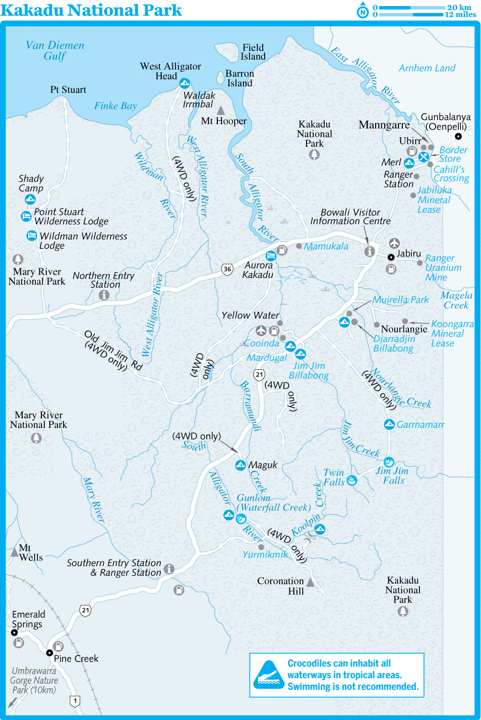
Geography
The circuitous Arnhem Land escarpment, a dramatic 30m- to 200m-high sandstone cliff line, forms the natural boundary between Kakadu and Arnhem Land and winds 500km through eastern and southeastern Kakadu.
Creeks cut across the rocky plateau and, in the wet season, tumble off it as thundering waterfalls. They then flow across the lowlands to swamp Kakadu's vast northern flood plains. From west to east, the rivers are the Wildman, West Alligator, South Alligator and East Alligator (the latter forming the eastern boundary of the park). The coastal zone has long stretches of mangrove swamp, important for halting erosion and as a breeding ground for bird and marine life. The southern part of the park is dry lowlands with open grassland and eucalyptuses. Pockets of monsoon rainforest crop up throughout the park.
More than 80% of Kakadu is savannah woodland. It has more than 1000 plant species, many still used by Aboriginal people for food and medicinal purposes.
URANIUM MINING
It's no small irony that some of the world's biggest deposits of uranium lie within one of Australia's most beautiful national parks. In 1953 uranium was discovered in the Kakadu region. Twelve small deposits in the southern reaches of the park were worked in the 1960s, but were abandoned following the declaration of Woolwonga Wildlife Sanctuary.
In 1970 three huge deposits − Ranger, Nabarlek and Koongarra − were found, followed by Jabiluka in 1971. The Nabarlek deposit (in Arnhem Land) was mined in the late 1970s, and the Ranger Uranium Mine started producing ore in 1981.
While all mining in the park has been controversial, it was Jabiluka that brought international attention to Kakadu and pitted conservationists and Indigenous owners against the government and mining companies. After uranium was discovered at Jabiluka in 1971, an agreement to mine was negotiated with the local Aboriginal peoples. The Jabiluka mine became the scene of sit-in demonstrations during 1998 that resulted in large-scale arrests. In 2003 stockpiled ore was returned into the mine and the decline tunnel leading into the deposit was backfilled as the mining company moved into dialogue with the traditional landowners, the Mirrar people. In February 2005 the current owners of the Jabiluka mining lease, Energy Resources of Australia (ERA), signed an agreement that gave the Mirrar the deciding vote on any resumption of this controversial mining project. Under the deal ERA is allowed to continue to explore the lease, subject to Mirrar consent.
In 2011 the traditional owners of the Koongarra lease, near Nourlangie, rejected the promise of millions of dollars from French nuclear-power conglomerate Areva and requested the land be integrated into the national park, which was completed in early 2013.
Meanwhile, the Ranger mine − which is officially not part of the national park but is surrounded by it − was mired in controversy in 2014 after safety concerns that included a toxic leak and collapsed ventilation shaft. There are plans for an underground expansion of the mine, although given recent events this is not guaranteed. Under current legislation it is due to close in 2021, with rehabilitation complete by 2026.
Climate
The average maximum temperature in Kakadu is 34°C, year-round. The Dry is roughly April to September, and the Wet, when most of Kakadu's average rainfall of 1500mm falls, is from October to March. As wetlands and waterfalls swell, unsealed roads become impassable, cutting off some highlights such as Jim Jim Falls.
Local Aboriginal people recognise six seasons in the annual cycle:
Gunumeleng (October to December) The build-up to the Wet. Humidity increases, the temperature rises to 35°C or more and mosquitoes reach near-plague proportions. By November the thunderstorms have started, billabongs are replenished, and waterbirds and fish disperse.
Gudjewg (January to March) The Wet proper continues, with violent thunderstorms, and flora and fauna thriving in the hot, moist conditions.
Banggerreng (April) Storms (known as 'knock 'em down' storms) flatten the spear grass, which during the course of the Wet has shot up to 2m high.
Yegge (May to June) The season of mists, when the air starts to dry out. The wetlands and waterfalls still have a lot of water and most of the tracks are open. The first firing of the countryside begins.
Wurrgeng (June to mid-August) The most comfortable time, weatherwise, is the late Dry, beginning in July. This is when animals, especially birds, gather in large numbers around shrinking billabongs, and when most tourists visit.
Gurrung (mid-August to September) The end of the Dry and the beginning of another cycle.
Wildlife
Kakadu has more than 60 species of mammal, more than 280 bird species, 120 recorded species of reptile, 25 species of frog, 55 freshwater fish species and at least 10,000 different kinds of insect. Most visitors see only a fraction of these creatures (except the insects), since many of them are shy, nocturnal or scarce.
Birds
Abundant waterbirds and their beautiful wetland homes are a highlight of Kakadu. This is one of the chief refuges in Australia for several species, including the magpie goose, green pygmy goose and Burdekin duck. Other fine waterbirds include pelicans, brolgas and the jabiru (or more correctly black-necked stork), Australia's only stork, with distinctive red legs and long beak. Herons, egrets, cormorants, wedge-tailed eagles, whistling kites and black kites are common. The open woodlands harbour rainbow bee-eaters, kingfishers and the endangered bustard. Majestic white-breasted sea eagles are seen near inland waterways. At night, you might hear barking owls calling − they sound just like dogs − or the plaintive wail of the bush stone curlew. The raucous call of the spectacular red-tailed black cockatoo is often considered the signature sound of Kakadu.
At Mamukala, 8km east of the South Alligator River on the Arnhem Hwy, is a wonderful observation building, plus birdwatching hides and a 3km walking track.
Fish
You can't miss the silver barramundi, which creates a distinctive swirl near the water's surface. A renowned sportfish, it can grow to more than 1m in length and changes sex from male to female at the age of five or six years.
Mammals
Several types of kangaroo and wallaby inhabit the park; the shy black wallaroo is unique to Kakadu and Arnhem Land: look for them at Nourlangie Rock, where individuals rest under rocky overhangs. At Ubirr, short-eared rock wallabies can be spotted in the early morning. You may see a sugar glider or a shy dingo in wooded areas in the daytime. Kakadu has 26 bat species, four of them endangered.
Reptiles
Twin Falls and Jim Jim Falls have resident freshwater crocodiles, which have narrow snouts and rarely exceed 3m, while the dangerous saltwater variety is found throughout the park.
Kakadu's other reptiles include the frilled lizard, 11 species of goanna, and five freshwater turtle species, of which the most common is the northern snake-necked turtle. Kakadu has many snakes, though most are nocturnal and rarely encountered. The striking Oenpelli python was first recorded by non-Aboriginal people in 1976. The odd-looking file snake lives in billabongs and is much sought after as bush tucker (food). They have square heads, tiny eyes and saggy skin covered in tiny rough scales (hence 'file'). They move very slowly (and not at all on land), eating only once a month and breeding once every decade.
Rock Art
Kakadu is one of Australia's richest, most accessible repositories of rock art. There are more than 5000 sites, which date from 20,000 years to 10 years ago. The vast majority of these sites are off limits or inaccessible, but two of the finest collections are the easily visited galleries at Ubirr and Nourlangie.
Rock paintings have been classified into three roughly defined periods: Pre-estuarine, which is from the earliest paintings up to around 6000 years ago; Estuarine, which covers the period from 6000 to around 2000 years ago, when rising sea levels brought the coast to its present level; and Freshwater, from 2000 years ago until the present day.
For local Aboriginal people, these rock-art sites are a major source of traditional knowledge and represent their archives. Aboriginal people rarely paint on rocks anymore, as they no longer live in rock shelters and there are fewer people with the requisite knowledge. Some older paintings are believed by many Aboriginal people to have been painted by mimi spirits, connecting people with creation legends and the development of Aboriginal lore.
As the paintings are all rendered with natural, water-soluble ochres, they are very susceptible to water damage. Drip lines of clear silicon rubber have been laid on the rocks above the paintings to divert rain. As the most accessible sites receive up to 4000 visitors a week, boardwalks have been erected to keep the dust down and to keep people at a suitable distance from the paintings.
TTours
There are dozens of Kakadu tours on offer; book at least a day ahead if possible.There are plenty of tours departing Darwin. Operators generally collect you from your accommodation. Keep an eye out for excellent, short ranger-led tours and activities throughout the park.
Indigenous Tours & Sightseeing
Kakadu Animal TracksCULTURAL TOUR
(![]() %0409 350
842; www.animaltracks.com.au;
adult/child
$205/135)
%0409 350
842; www.animaltracks.com.au;
adult/child
$205/135)![]() S
S
Based at Cooinda, this outfit runs seven-hour tours with an Indigenous guide combining a wildlife safari and Aboriginal cultural tour. You'll see thousands of birds, get to hunt, gather, prepare and consume bush tucker, and crunch on some green ants.
Arnhemlander Cultural & Heritage TourCULTURAL TOUR
(![]() %08-8979
2548; www.kakadutours.com.au;
adult/child
$258/205)
%08-8979
2548; www.kakadutours.com.au;
adult/child
$258/205)![]() S
S
Aboriginal-owned and -operated tour into northern Kakadu and Arnhem Land. See ancient rock art, learn bush skills and meet local artists at Injalak Arts Centre in Oenpelli.
Top End Explorer ToursOUTDOORS
(![]() %08-8979
3615; www.kakadutours.net.au;
adult/child
$230/170)
%08-8979
3615; www.kakadutours.net.au;
adult/child
$230/170)
Small-group 4WD tours to Jim Jim and Twin Falls from Jabiru and Cooinda.
Ayal Aboriginal ToursCULTURAL TOUR
(![]() %0429 470
384; www.ayalkakadu.com.au;
adult/child $220/99)
%0429 470
384; www.ayalkakadu.com.au;
adult/child $220/99)![]() S
S
Full-day Indigenous-run tours around Kakadu, with former ranger and local Victor Cooper, shining a light on art, culture and wildlife.
Kakadu AirSCENIC FLIGHTS
(![]() %1800 089 113,
08-8941 9611;
www.kakaduair.com.au)
%1800 089 113,
08-8941 9611;
www.kakaduair.com.au)
Offers 30-minute/one-hour fixed-wing flights for $150/250 per adult. Helicopter tours, though more expensive, give a more dynamic aerial perspective. They cost from $230 (20 minutes) to $650 (one hour) per person. Note that flights are only available over Jim Jim Falls in the wet season – traditional owners request that the 'skies are rested' in the Dry.
Wetland & River Trips
Yellow Water CruisesCRUISE
(![]() %1800 500
401; www.gagudju-dreaming.com)
%1800 500
401; www.gagudju-dreaming.com)
Cruise the South Alligator River and Yellow Water Billabong spotting wildlife. Purchase tickets from Gagudju Lodge, Cooinda; a shuttle bus will take you from here to the tour's departure point. Two-hour cruises ($99/70 per adult/child) depart at 6.45am, 9am and 4.30pm; 1½-hour cruises ($72/50) leave at 11.30am, 1.15pm and 2.45pm.
Guluyambi Cultural CruiseCULTURAL TOUR
(www.aptouring.com.au/KCT;
adult/child $72/48; ![]() h9am, 11am,
1pm & 3pm May-Nov)
h9am, 11am,
1pm & 3pm May-Nov)![]() S
S
Launch into an Aboriginal-led river cruise from the upstream boat ramp on the East Alligator River near Cahill's Crossing. Highly recommended by Darwin locals.
Ubirr & Around
It'll take a lot more than the busloads of
visitors to disturb the inherent majesty and grace of Ubirr (
GOOGLE MAP ;
![]() h8.30am-sunset
Apr-Nov, from 2pm Dec-Mar). Layers of rock-art
paintings, in various styles and from various centuries,
command a mesmerising stillness. Part of the main gallery reads
like a menu, with images of kangaroos, tortoises and fish painted
in x-ray, which became the dominant style about 8000 years ago.
Predating these are the paintings of mimi spirits: cheeky, dynamic
figures who, it's believed, were the first of the Creation
Ancestors to paint on rock (...given the lack of cherry pickers in
6000 BC, you have to wonder who else but a spirit could have
painted at that height and angle). Look out for the yam-head
figures, where the head is depicted as a yam on the body of a human
or animal; these date back around 15,000 years.
h8.30am-sunset
Apr-Nov, from 2pm Dec-Mar). Layers of rock-art
paintings, in various styles and from various centuries,
command a mesmerising stillness. Part of the main gallery reads
like a menu, with images of kangaroos, tortoises and fish painted
in x-ray, which became the dominant style about 8000 years ago.
Predating these are the paintings of mimi spirits: cheeky, dynamic
figures who, it's believed, were the first of the Creation
Ancestors to paint on rock (...given the lack of cherry pickers in
6000 BC, you have to wonder who else but a spirit could have
painted at that height and angle). Look out for the yam-head
figures, where the head is depicted as a yam on the body of a human
or animal; these date back around 15,000 years.
The magnificent Nardab Lookout is a 250m scramble from the main gallery. Surveying the billiard-table-green floodplain and watching the sun set and the moon rise, like they're on an invisible set of scales, is glorious, to say the least. Ubirr is 39km north of the Arnhem Hwy via a sealed road.
On the way you'll pass the turn-off to
Merl (
GOOGLE MAP ; adult/child
$10/free) camping
ground, which is only open in the Dry and has an amenities block
and BBQs, and the Border Store
(
GOOGLE MAP ; ![]() %08-8979
2474; mains $20-28;
%08-8979
2474; mains $20-28; ![]() h8.30am-8pm
Apr-Nov), selling
groceries, real coffee, and delicious Thai food (no fuel).
h8.30am-8pm
Apr-Nov), selling
groceries, real coffee, and delicious Thai food (no fuel).
2Activities
Bardedjilidji Sandstone WalkWALKING
Starting from the upstream picnic-area car park, this walk (2.5km, 90 minutes, easy) takes in wetland areas of the East Alligator River and some interesting eroded sandstone outliers of the Arnhem Land escarpment. Informative track notes point out features on this walk.
Manngarre Monsoon Forest WalkWALKING
Mainly sticking to a boardwalk, this walk (1.5km return, 30 minutes, easy) starts by the boat ramp near the Border Store and winds through heavily shaded vegetation, palms and vines.
Sandstone & River Rock HolesWALKING
This extension (6.5km, three hours, medium) of the Bardedjilidji Walk features sandstone outcrops, paperbark swamps and riverbanks. Closed in the Wet.
Jabiru
Pop 1129
It may seem surprising to find a town of Jabiru's size and structure in the midst of a wilderness national park, but it exists solely because of the nearby Ranger uranium mine. It's Kakadu's major service centre, with a bank, newsagent, medical centre, supermarket, bakery and service station. You can even play a round of golf here.
zFestivals & Events
Mahbilil FestivalCULTURAL
A one-day celebration in early September of indigenous culture in Jabiru. There are exhibitions showcasing local art as well as craft demonstrations, including weaving and painting. Also on offer are competitions in spear throwing, didgeridoo blowing and magpie goose cooking. In the evening the focus is on indigenous music and dance.
4Sleeping & Eating
![]() oAnbinik
(Lakeview) ResortCABINS
oAnbinik
(Lakeview) ResortCABINS
(
GOOGLE MAP ; ![]() %08-8979
3144; www.lakeviewkakadu.com.au;
27 Lakeside Dr; en-suite
powered sites $40, bungalows/d/cabins
$130/140/245;
%08-8979
3144; www.lakeviewkakadu.com.au;
27 Lakeside Dr; en-suite
powered sites $40, bungalows/d/cabins
$130/140/245;
![]() a
a![]() s)
s)
This Aboriginal-owned park is one of Kakadu's best with a range of tropical-design bungalows set in lush gardens. The doubles share a communal kitchen, bathroom and lounge, and also come equipped with their own TV and fridge. The 'bush bungalows' are stylish, elevated safari designs (no air-con) with private external bathroom. Bungalows sleep up to four. By far the best value in Jabiru.
Aurora Kakadu Lodge & Caravan ParkRESORT
(
GOOGLE MAP ; ![]() %08-8979 2422,
1800 811 154;
www.auroraresorts.com.au;
Jabiru Dr; unpowered/powered sites $28/40, cabins from
$250;
%08-8979 2422,
1800 811 154;
www.auroraresorts.com.au;
Jabiru Dr; unpowered/powered sites $28/40, cabins from
$250; ![]() a
a![]() i
i![]() s)
s)
One of the best places to camp in town with lots of grass, trees and natural barriers between camping areas, creating a sense of privacy. This impeccable resort/caravan park also has a lagoon-style swimming pool. Self-contained cabins sleep up to five people. The restaurant is a lovely outdoor place for meals overlooking the pool. The menu is limited but dishes such as buffalo sausages are well prepared.
Mercure Kakadu (Crocodile Hotel)HOTEL
(
GOOGLE MAP ; ![]() %08-8979
9000; www.accorhotels.com;
1 Flinders St; d from
$310;
%08-8979
9000; www.accorhotels.com;
1 Flinders St; d from
$310; ![]() a
a![]() W
W![]() s)
s)
Known locally as 'the Croc', this hotel is designed in the shape of a crocodile, which, of course, is only obvious when viewed from the air or Google Earth. The rooms are clean and comfortable if a little pedestrian for the price (check its website for great deals). Try for one on the ground floor opening out to the central pool.
Kakadu BakeryBAKERY
(
GOOGLE MAP ; Gregory
Pl; meals $6-15; ![]() h6am-3pm
Mon-Fri, 8am-3.30pm Sat, 8am-4pm Sun)
h6am-3pm
Mon-Fri, 8am-3.30pm Sat, 8am-4pm Sun)
Superb made-to-order sandwiches on home-baked bread walk out the door. There are also mean burgers, slices, breakfast fry-ups, pizzas, cakes and basic salads.
Jabiru Sports & Social ClubPUB FOOD
(
GOOGLE MAP ; ![]() %08-8979
2326; Lakeside Dr; mains
$16-35;
%08-8979
2326; Lakeside Dr; mains
$16-35; ![]() hnoon-2pm
Thu-Sun, 6-8.30pm Tue-Sat)
hnoon-2pm
Thu-Sun, 6-8.30pm Tue-Sat)
Along with the golf club, this low-slung hangar is the place to meet locals over a beer or glass of wine. The bistro meals, such as steak, chicken parma or fish and chips, are honest, and there's an outdoor deck overlooking the lake, a kids playground, and sport on TV.
Nourlangie
The sight of this looming outlier of the Arnhem Land escarpment makes it easy to understand its ancient importance to Aboriginal people. Its long red-sandstone bulk, striped in places with orange, white and black, slopes up from surrounding woodland to fall away at one end in stepped cliffs. Below is Kakadu's best-known collection of rock art.
The name Nourlangie is a corruption of nawulandja, an Aboriginal word that refers to an area bigger than the rock itself. The 2km looped walking track (open 8am to sunset) takes you first to the Anbangbang Shelter, used for 20,000 years as a refuge and canvas. Next is the Anbangbang Gallery, featuring Dreaming characters repainted in the 1960s. Look for the virile Nabulwinjbulwinj, a dangerous spirit who likes to eat females after banging them on the head with a yam. From here it's a short walk to Gunwarddehwarde Lookout, with views of the Arnhem Land escarpment.
Nourlangie is at the end of a 12km sealed road that turns east off Kakadu Hwy. About 7km south is the turn-off to Muirella Park (adult/child $10/free) camping ground at Djarradjin Billabong, with BBQs, excellent amenities and the 5km-return Bubba Wetland Walk.
2Activities
Nawurlandja LookoutWALKING
This is a short walk (600m return, 30 minutes, medium) up a gradual slope, but it gives excellent views of the Nourlangie rock area and is a good place to catch the sunset.
Anbangbang Billabong WalkWALKING
This picturesque, lily-filled billabong lies close to Nourlangie, and the picnic tables dotted around its edge make it a popular lunch spot. The track (2.5km loop, 45 minutes, easy) circles the billabong and passes through paperbark swamp.
Barrk WalkWALKING
This long day walk (12km loop, five to six hours, difficult) will take you away from the crowds on a circuit of the Nourlangie area. Barrk is the male black wallaroo and you might see this elusive marsupial if you set out early. Pick up a brochure from the Bowali Visitor Information Centre.
Starting at the Nourlangie car park, this demanding walk passes through the Anbangbang galleries before a steep climb to the top of Nourlangie Rock. Cross the flat top of the rock weaving through sandstone pillars before descending along a wet-season watercourse. The track then follows the rock's base past the Nanguluwur Gallery and western cliffs before re-emerging at the car park.
Nanguluwur GalleryWALKING
This outstanding rock-art gallery sees far fewer visitors than Nourlangie simply because it's further to walk (3.5km return, 1½ hours, easy) and has a gravel access road. Here the paintings cover most of the styles found in the park, including very early dynamic style work, x-ray work and a good example of 'contact art', a painting of a two-masted sailing ship towing a dinghy.
Jim Jim Falls & Twin Falls
Remote and spectacular, these two falls epitomise the rugged Top End. Jim Jim Falls, a sheer 215m drop, is awesome after rain (when it can only be seen from the air), but its waters shrink to a trickle by about June. Twin Falls flows year-round (no swimming), but half the fun is getting here, involving a little boat trip (adult/child $12.50/free, running 7.30am to 5pm, last boat 4pm) and an over-the-water boardwalk.
These two iconic waterfalls are reached via a 4WD track that turns south off the Kakadu Hwy between the Nourlangie and Cooinda turn-offs. Jim Jim Falls is about 56km from the turn-off (the last 1km on foot), and it's a further five corrugated kilometres to Twin Falls. The track is open in the Dry only and can still be closed into late May; it's off limits to most rental vehicles (check the fine print). A couple of tour companies make trips here in the Dry and there's a camping area, Garrnamarr (adult/child $10/free) near Jim Jim Falls.
Cooinda & Yellow Water
Cooinda is best known for the
cruises on the wetland area known as Yellow Water, and has
developed into a slick resort. About 1km from the resort, the
Warradjan Aboriginal Cultural Centre
(www.gagudju-dreaming.com;
Yellow Water Area; ![]() h9am-5pm) depicts Creation stories and has a great
permanent exhibition that includes clap sticks, sugar-bag holders
and rock-art samples. You'll be introduced to the moiety system
(the law of interpersonal relationships), languages and skin names,
and there's a minitheatre with a huge selection of films from which
to choose. A mesmeric soundtrack of chants and didgeridoos plays in
the background.
h9am-5pm) depicts Creation stories and has a great
permanent exhibition that includes clap sticks, sugar-bag holders
and rock-art samples. You'll be introduced to the moiety system
(the law of interpersonal relationships), languages and skin names,
and there's a minitheatre with a huge selection of films from which
to choose. A mesmeric soundtrack of chants and didgeridoos plays in
the background.
Gagudju Lodge & Camping Cooinda (![]() %1800 500
401; www.gagudju-dreaming.com;
Cooinda; unpowered/powered sites $38/50, budget/lodge r
from $75/310;
%1800 500
401; www.gagudju-dreaming.com;
Cooinda; unpowered/powered sites $38/50, budget/lodge r
from $75/310;
![]() a
a![]() i
i![]() s) is
the most popular accommodation resort in the park. It's a modern
oasis but, even with 380 camp sites, facilities can get very
stretched. The budget air-con units share camping ground facilities
and are compact and comfy enough. The lodge rooms are spacious and
more comfortable, sleeping up to four people. There's also a
grocery shop, tour desk, fuel pump and the excellent open-air
Barra Bar & Bistro (
s) is
the most popular accommodation resort in the park. It's a modern
oasis but, even with 380 camp sites, facilities can get very
stretched. The budget air-con units share camping ground facilities
and are compact and comfy enough. The lodge rooms are spacious and
more comfortable, sleeping up to four people. There's also a
grocery shop, tour desk, fuel pump and the excellent open-air
Barra Bar & Bistro (![]() %1800 500
401; www.gagudju-dreaming.com;
Cooinda; mains
$15-36;
%1800 500
401; www.gagudju-dreaming.com;
Cooinda; mains
$15-36; ![]() hall
day) here.
hall
day) here.
The turn-off to the Cooinda accommodation complex and Yellow Water wetlands is 47km down the Kakadu Hwy from the Arnhem Hwy intersection. Just off the Kakadu Hwy, 2km south of the Cooinda turn-off, is the scrubby Mardugal camping ground (adult/child $10/free), an excellent year-round camping area with shower and toilets.
Cooinda to Pine Creek
This southern section of the park sees far fewer tour buses. Though it's unlikely you'll have dreamy Maguk (Barramundi Gorge; 45km south of Cooinda and 10km along a corrugated 4WD track) to yourself, you might time it right to have the glorious natural pool and falls between just a few of you. Forty-odd kilometres further south is the turn-off to Gunlom (Waterfall Creek), another superb escarpment waterfall, plunge pool and camping area. It's located 37km along an unsealed road, again 4WD recommended. Take the steep Waterfall Walk (1km, one hour) here, which affords incredible views.
8Information
About 200,000 people visit Kakadu between April and October, so expect some tour-bus action at sites such as Ubirr and Yellow Water. Consider spending some time bushwalking and camping in the south of the park − it's less visited but inimitably impressive.
Admission to the park is via a 14-day Park Pass (adult $25, child free). Pick up a pass, along with the excellent Visitor Guide booklet, from Bowali Visitor Information Centre, Tourism Top End in Darwin, Gagudju Lodge Cooinda or Katherine Visitor Information Centre. Carry it with you at all times, as rangers conduct spot checks – penalties apply for nonpayment. Fuel is available at Kakadu Resort, Cooinda and Jabiru.
Accommodation prices in Kakadu vary tremendously depending on the season − resort rates can drop by as much as 50% during the Wet.
The excellent Bowali
Visitor Information Centre (![]() %08-8938
1121;
www.kakadunationalparkaustralia.com/bowali_visitors_center.htm;
Kakadu Hwy, Jabiru;
%08-8938
1121;
www.kakadunationalparkaustralia.com/bowali_visitors_center.htm;
Kakadu Hwy, Jabiru; ![]() h8am-5pm) has walk-through displays that sweep you
across the land, explaining Kakadu's ecology from Aboriginal and
non-Aboriginal perspectives. The centre is about 2.5km south of the
Arnhem Hwy intersection; a 1km walking track connects it with
Jabiru.
h8am-5pm) has walk-through displays that sweep you
across the land, explaining Kakadu's ecology from Aboriginal and
non-Aboriginal perspectives. The centre is about 2.5km south of the
Arnhem Hwy intersection; a 1km walking track connects it with
Jabiru.
A great online site is Kakadu National Park (www.kakadu.au), which has a visitors guide, what's on listings and suggested itineraries to download.
The Northern Land Council issues permits (adult/child $18/free) to visit Gunbalanya (Oenpelli), across the East Alligator River.
8Getting There & Around
Many people choose to access Kakadu on a tour, which shuffles them around the major sights with the minimum of hassle. But it's just as easy with your own wheels, if you know what kinds of road conditions your trusty steed can handle (Jim Jim and Twin Falls, for example, are 4WD-access only).
Greyhound Australia (www.greyhound.com.au) runs a return coach service from Darwin to Jabiru ($66, 3½ hours).
Arnhem Land
Arnhem Land is a vast, overwhelming and mysterious corner of the NT. About the size of the state of Victoria and with a population of only around 17,000, mostly Yolngu people, this Aboriginal reserve is one of Australia's last great untouched wilderness areas. Most people live on outstations, combining traditional practices with modern Western ones, so they might go out for a hunt and be back in time to watch the 6pm news. Outside commercial interests and visits are highly regulated through a permit system, designed to protect the environment, the rock art and ceremonial grounds. Balanda (white people) are unaware of the locations of burial grounds and ceremonial lands. Basically, you need a specific purpose for entering, usually to visit an arts centre, in order to be granted a permit. If you're travelling far enough to warrant an overnight stay, you'll need to organise accommodation (which is in short supply). It's easy to visit Gunbalanya (Oenpelli) and its arts centre, just over the border, either on a tour or independently. Elsewhere, it's best to travel with a tour, which will include the necessary permit(s) to enter Aboriginal lands.
TTours
Arnhemlander Cultural & Heritage TourTOUR
(![]() %1800 665
220; www.aptouring.com.au/KCT;
adult/child
$258/205)
%1800 665
220; www.aptouring.com.au/KCT;
adult/child
$258/205)
Four-wheel-drive tours to ancient rock-art sites, Inkiyu Billabong and Injalak art centre at Gunbalanya (Oenpelli).
Davidson's Arnhemland SafarisCULTURAL TOUR
(![]() %08-8979
0413; www.arnhemland-safaris.com)
%08-8979
0413; www.arnhemland-safaris.com)
Experienced operator taking tours to Mt Borradaile, north of Oenpelli. Meals, guided tours, fishing and safari-camp accommodation are included in the daily price (from $750); transfers from Darwin can be arranged.
Venture North AustraliaTOUR
(![]() %08-8927
5500; venturenorth.com.au;
4-/5-day tours
$2590/2890)
%08-8927
5500; venturenorth.com.au;
4-/5-day tours
$2590/2890)
Four-wheel drive tours to remote areas; features expert guidance on rock art. Also has a safari camp near Smith Point on the Cobourg Peninsula.
Lord's Kakadu & Arnhemland SafarisTOUR
(![]() %08-8948
2200; www.lords-safaris.com;
adult/child
$225/180)
%08-8948
2200; www.lords-safaris.com;
adult/child
$225/180)
One-day trip into Arnhem Land (Gunbalanya) from Jabiru (or Darwin adult/child $255/195), visiting Oenpelli with an Aboriginal-guided walk around Injalak Hill rock-art site.
Nomad ToursTOUR
(![]() %08-8987
8085; www.banubanu.com; beach
camping/cabin per person per day $80/550)
%08-8987
8085; www.banubanu.com; beach
camping/cabin per person per day $80/550)
Luxury small-group tours including fishing charters, 4WD and cultural tours. Transfers and guided activities are available for an extra fee.
Gove Diving & Fishing ChartersFISHING
(![]() %08-8987
3445; www.govefish.com.au)
%08-8987
3445; www.govefish.com.au)
Variety of fishing, diving and snorkelling, and wilderness trips from Nhulunbuy. Half-/full-day fishing trips cost $225/325.
Gunbalanya (Oenpelli)
Pop 1121
Gunbalanya is a small Aboriginal community 17km into Arnhem Land across the East Alligator River from the Border Store in Kakadu. The drive in itself is worth the trip, with brilliant green wetlands and spectacular escarpments all around. Road access is only possible between May and October: check the tides at Cahill's Crossing on the East Alligator River before setting out so you don't get stuck on the other side.
A permit is required to visit the town,
usually issued for visits to the Injalak Arts
& Crafts Centre (![]() %08-8979
0190; www.injalak.com;
%08-8979
0190; www.injalak.com; ![]() h8am-5pm
Mon-Fri, 9am-2pm Sat).
At this centre, artists and craftspeople display traditional
paintings on bark and paper, plus didgeridoos, pandanus weavings
and baskets, and screen-printed fabrics. Artworks are produced
either at the arts centre itself or on remote outstations
throughout Arnhem Land.
h8am-5pm
Mon-Fri, 9am-2pm Sat).
At this centre, artists and craftspeople display traditional
paintings on bark and paper, plus didgeridoos, pandanus weavings
and baskets, and screen-printed fabrics. Artworks are produced
either at the arts centre itself or on remote outstations
throughout Arnhem Land.
As you walk around the verandah of the arts centre to see the artists at work (morning only), peer out over the wetland at the rear to the escarpment and Injalak Hill (Long Tom Dreaming). Knowledgeable local guides lead tours to see the fine rock-art galleries here. The three-hour tours cost $110/33 per adult/child. Although it may be possible to join a tour as a walk-in, it's generally best to book a tour from Jabiru or Darwin.
The Stone Country Festival is an open day and cultural festival held in August. It has traditional music, dancing, and arts and crafts demonstrations, and is the only day you can visit Gunbalanya without a permit. Camping allowed; no alcohol.
The Northern Land
Council (![]() %1800 645 299,
08-8938 3000;
www.nlc.org.au; 3 Government
Bldg, Flinders St, Jabiru;
%1800 645 299,
08-8938 3000;
www.nlc.org.au; 3 Government
Bldg, Flinders St, Jabiru; ![]() h8am-4.30pm
Mon-Fri) issues permits
(adult/child $16.50/free) to visit Injalak, usually on the spot. It
also provides tide times for the East Alligator River, which is
impassable at high tide.
h8am-4.30pm
Mon-Fri) issues permits
(adult/child $16.50/free) to visit Injalak, usually on the spot. It
also provides tide times for the East Alligator River, which is
impassable at high tide.
Cobourg Peninsula
The entire wilderness of this remote peninsula forms the Garig Gunak Barlu National Park (www.parksandwildlife.nt.gov.au/parks/find/gariggunak), which includes the surrounding sea. In the turquoise water you'll likely see dolphins and turtles, and − what most people come for − a threadfin salmon thrashing on the end of your line.
On the shores of Port Essington are the stone ruins and headstones of Victoria settlement, Britain's 1838 attempt to establish a military outpost here.
At Algarlarlgarl (Black
Point) there's a ranger station
(![]() %08-8979
0244) with a visitor
information and cultural centre, and the Garig
Store (
%08-8979
0244) with a visitor
information and cultural centre, and the Garig
Store (![]() %08-8979
0455; Algarlarlgarl (Black Point);
%08-8979
0455; Algarlarlgarl (Black Point); ![]() h4-6pm
Mon-Sat), which sells
basic provisions, ice and camping gas.
h4-6pm
Mon-Sat), which sells
basic provisions, ice and camping gas.
Two permits are required to visit the Cobourg
Peninsula: for a transit pass ($12.10 per vehicle) to drive through
Aboriginal land contact the
Northern Land Council; for permission to stay overnight in the
national park contact the Cobourg Peninsula
Sanctuary & Marine Park Board (![]() %08-8999
4814; www.parksandwildlife.nt.gov.au/parks/find/gariggunak).
The overnight fee is $232.10 per vehicle, which covers up to five
people for seven days and includes a camping and transit pass.
%08-8999
4814; www.parksandwildlife.nt.gov.au/parks/find/gariggunak).
The overnight fee is $232.10 per vehicle, which covers up to five
people for seven days and includes a camping and transit pass.
There are two camping grounds in the park with shower, toilet, BBQs and limited bore water; generators are allowed in one area. Camping fees (per person per day $16.50) are covered by your vehicle permit, but if you fly in you'll have to pay them. Other accommodation is available in pricey fishing resorts.
8Getting There & Away
The quickest route here is by private charter flight, which can be arranged by accommodation providers. The track to Cobourg starts at Gunbalanya (Oenpelli) and is accessible by 4WD vehicles only from May to October. The 270km drive to Black Point from the East Alligator River takes about four hours.
Eastern Arnhem Land
The wildly beautiful coast and country of Eastern Arnhem Land (www.ealta.org) is really off the beaten track. About 4000 people live in the region's main settlement, Nhulunbuy, built to service the bauxite mine here. The 1963 plans to establish a manganese mine were hotly protested by the traditional owners, the Yolngu people; though mining proceeded, the case became an important step in establishing land rights. Some of the country's most respected art comes out of this region too, including bark paintings, carved mimi figures, yidaki (didgeridoos), woven baskets and mats, and jewellery.
Buku Larrnggay Mulka Art
Centre & Museum (www.yirrkala.com; Yirrkala; by
donation; ![]() h8am-4.30pm
Mon-Fri, 9am-noon Sat),
20km southeast of Nhulunbuy in Yirrkala, is one of Arnhem Land's
best. No permit is required to visit from Nhulunbuy or Gove
airport.
h8am-4.30pm
Mon-Fri, 9am-noon Sat),
20km southeast of Nhulunbuy in Yirrkala, is one of Arnhem Land's
best. No permit is required to visit from Nhulunbuy or Gove
airport.
In August, the Garma Fesival (www.yyf.com.au) is a four-day celebration in northeastern Arnhem Land. It's one of the most significant regional festivals, a celebration of Yolngu culture that includes ceremonial performances, bushcraft lessons, a yidaki (didgeridoo) master class and an academic forum. Serious planning is required to attend, so start early.
Overland travel through Arnhem Land from
Katherine requires a permit (free) from the
Northern Land Council. The Dhimurru Land
Management Aboriginal Corporation (![]() %08-8987
3992; www.dhimurru.com.au;
Arnhem Rd,
Nhulunbuy) issues
recreation permits ($35/45 for seven days/two months) for visits to
particular recreational areas in Eastern Arnhem Land − check the
website for details.
%08-8987
3992; www.dhimurru.com.au;
Arnhem Rd,
Nhulunbuy) issues
recreation permits ($35/45 for seven days/two months) for visits to
particular recreational areas in Eastern Arnhem Land − check the
website for details.
8Getting There & Away
Airnorth
(![]() %1800 627
474; www.airnorth.com.au)
and
Qantaslink fly from Darwin to Gove Airport (for Nhulunbuy)
daily from $355 one way. Overland, it's a 10-hour 4WD trip and only
possible in the Dry. The Central Arnhem Hwy to Gove leaves the
Stuart Hwy (Rte 87) 52km south of Katherine. At the time of writing
Sea Swift (
%1800 627
474; www.airnorth.com.au)
and
Qantaslink fly from Darwin to Gove Airport (for Nhulunbuy)
daily from $355 one way. Overland, it's a 10-hour 4WD trip and only
possible in the Dry. The Central Arnhem Hwy to Gove leaves the
Stuart Hwy (Rte 87) 52km south of Katherine. At the time of writing
Sea Swift (![]() %08-8935 2400,
1800 424 422;
www.seaswift.com.au)
was launching a cruise service aboard a working cargo boat from
Darwin to Gove.
%08-8935 2400,
1800 424 422;
www.seaswift.com.au)
was launching a cruise service aboard a working cargo boat from
Darwin to Gove.