Plan Your Trip
Your Outback Trip
Exactly where Australia’s outback starts and ends is hard to pin down on a map. But you’ll know you're there when the sky yawns enormously wide, the horizon is unnervingly empty, and the sparse inhabitants you encounter are incomparably resilient and distinctively Australian. Enduring Indigenous culture, unique wildlife and intriguing landscapes await the modern-day adventurer.
Best Outback Experiences
Things to Pack
Sunscreen, sunglasses, a hat, insect repellent, plenty of water and some good tunes for the car stereo.
Best Outback Track
The Oodnadatta Track is 620km of red dust, emus, lizards, salt lakes and historic railroad remnants.
Indigenous Culture
Kakadu National Park in the tropical Top End wilderness offers ancient rock art and cultural tours run by Indigenous guides.
Best National Park
In Uluru-Kata Tjuta National Park, iconic Uluru is simply unmissable, while nearby Kata Tjuta is less well known but just as impressive.
Best Outback Highway
Cross the country's outback heartland from Adelaide to Darwin on the Stuart Hwy.
About the Outback
The Australian outback is a vast, imprecise region radiating out from the centre of the continent. While most Australians live on the coast, that thin green fringe of the continent is hardly typical of this enormous land mass. Inland is the desert soul of Australia.
Weather patterns vary from region to region – from sandy arid desert to semi-arid scrubland to tropical savannah – but you can generally rely on hot sunny days, starry nights and mile after mile of unbroken horizon.
When to Go
Best Months
Winter June through August is when southeastern Australia (where most of the population lives) is sniffling through rainy and cloudy winter days, and the outback comes into its own. Rain isn't unheard of in central Australia – in fact there's been a hell of a lot of it over recent years – but clear skies, moderate daytime temperatures, cold nights and good driving conditions are the norm. Winter is also the best time to visit the tropical Top End, with low humidity, dry days and mild temperatures.
Spring September and October is springtime – and prime time to head into the outback, especially if you're into wildflowers. The MacDonnell Ranges near Alice Springs and the Flinders Ranges in northern South Australia (SA) erupt with colourful blooms, all the more dazzling in contrast with red-orange desert sands.
Avoid
Summer Central Australia heats up over summer (December through February) – temperatures approaching 50°C have been recorded in some desert towns – but that's just part of the picture. With the heat comes dusty roads, overheating cars, driver fatigue, irritating flies and the need to carry extra water everywhere you go. In the Top End the build-up to the Wet season is uncomfortably humid, and the eventual monsoon can see many a road cut and dirt roads made impassable for weeks at a time.
OUTBACK ROAD SHOW
On many outback highways you'll see thundering road trains: huge trucks (a prime mover plus two, three or four trailers) some more than 50m long. These things don't move over for anyone: it's like a scene from Mad Max having one bear down on you at 120km/h.
A few tips: when you see a road train approaching on a narrow bitumen road, slow down and pull over − if the truck has to put its wheels off the road to pass you, the resulting barrage of stones will almost certainly smash your windscreen. When trying to overtake one, allow plenty of room (about a kilometre) to complete the manoeuvre. Road trains throw up a lot of dust on dirt roads, so if you see one coming it's best to just pull over and stop until it's gone past.
And while you're on outback roads, don't forget to give the standard bush greeting to oncoming drivers − it's simply a matter of lifting the index finger off the steering wheel to acknowledge your fellow explorer.
Planes, Trains or Automobiles?
Air If you want to access the outback without a long drive, the major airlines fly into Alice Springs and Yulara (for the central deserts) and Darwin (for the tropical Top End), departing from Perth, Adelaide and the major east-coast cities. From Darwin or Alice you can join a guided tour or hire a 4WD and off you go.
Train Unlike much of the world, train travel in Australia is neither affordable nor expedient. It's something you do for a special occasion or for the sheer romance of trains, not if you want to get anywhere in a hurry. That said, travelling on the Indian Pacific between Perth and Sydney or the legendary Ghan between Adelaide and Darwin takes you through parts of the country you wouldn't see otherwise, and it certainly makes for a leisurely holiday. Train travel is also a good way to beat the heat if you're travelling in summer. So if you have time on your side and you can afford it, train travel could be perfect for you.
Car You can drive through the Red Centre from Darwin to Adelaide with detours to Uluru and Kakadu and more without ever leaving sealed roads. However, if you really want to see outback Australia, there are plenty of side routes that breathe new life into the phrase 'off the beaten track' (bring a 4WD). Driving in the outback has its challenges – immense distances and occasionally difficult terrain – but it's ultimately the most rewarding and intimate way to experience Australia's 'dead heart' (rest assured, it's alive and kicking!).
OUTBACK DRIVING & SAFETY CHECKLIST
Due to the lack of water, long distances between fuel stops and isolation, you need to be particularly organised and vigilant when travelling in the outback, especially on remote sandy tracks. Here are a few tips:
COMMUNICATION
AReport your route and schedule to the police, a friend or relative.
AMobile phones are pretty useless if you venture off the highway. Consider hiring a satellite phone, high-frequency (HF) radio transceiver equipped to pick up the Royal Flying Doctor Service bases, or emergency position-indicating radio beacon (EPIRB).
AIn an emergency, stay with your vehicle; it's easier to spot than you are, and you won't be able to carry a heavy load of water very far.
AIf you do become stranded, consider setting fire to a spare tyre (let the air out first). The pall of smoke will be visible for miles.
YOUR VEHICLE
AHave your vehicle serviced and checked before you leave.
ALoad your vehicle evenly, with heavy items inside and light items on the roof rack.
AConsider carrying spare fuel in an appropriate container.
ACarry essential tools: a spare tyre (two is preferable), fan belt, radiator hose, tyre-pressure gauge and air pump, and a shovel.
AAn off-road jack might come in handy, as will a snatchem strap or tow rope for quick extraction when you're stuck (useful if there's another vehicle to pull you out).
SUPPLIES & EQUIPMENT
ACarry plenty of water: in warm weather allow 5L per person per day and an extra amount for the radiator, carried in several containers.
ABring plenty of food in case of a breakdown.
ACarry a first-aid kit, a good set of maps, a torch with spare batteries, a compass and a GPS.
AFor updates on road conditions, see (Click here).
WEATHER & ROAD CONDITIONS
ACheck road conditions before travelling: roads that are passable in the Dry (March to October) can disappear beneath water during the Wet.
ADon't attempt to cross flooded bridges or causeways unless you're sure of the depth, and of any road damage hidden underwater.
DIRT-ROAD DRIVING
AInflate your tyres to the recommended levels for the terrain you're travelling on; on desert sand, deflate your tyres to 20-25psi to avoid getting bogged. Don't forget to re-inflate them when you leave the sand.
AReduce speed on unsealed roads, as traction is decreased and braking distances increase.
ADirt roads are often corrugated: keeping an even speed is the best approach.
ADust on outback roads can obscure your vision, so always stop and wait for it to settle.
AChoose a low gear for steep inclines and the lowest gear for steep declines. Use the brake sparingly and don't turn sideways on a hill.
ROAD HAZARDS
ATake a rest every few hours: driver fatigue is an all-too-common problem.
AWandering cattle, sheep, emus, kangaroos, camels etc make driving fast a dangerous prospect. Take care and avoid nocturnal driving, as this is often when native animals come out. Many car-hire companies prohibit night-time driving.
ARoad trains are an ever-present menace on the main highways. Give them a wide berth, they're much bigger than you!
Essential Outback
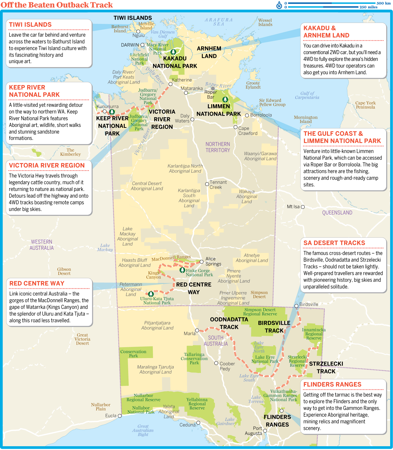
The Red Centre: Alice Springs, Uluru & Watarrka (Kings Canyon)
From Alice Springs it's a six-hour drive to Uluru-Kata Tjuta National Park. The Alice is a surprising oasis: big enough to have some great places to eat and stay, as well as some social problems. Uluru is to tourists what half a watermelon is to ants at a picnic: people from all over the globe swarm to and from this monolith at all times of the day. But it's still a remarkable find. The local Anangu people would prefer that you didn't climb it. Watarrka (Kings Canyon), about 300km north of Uluru, is a spectacular chasm carved into the rugged landscape.
The Stuart Highway: Adelaide to Darwin
In either direction, from the north or south, the Stuart Hwy is one of Australia's greatest road trips: 3020km of red desert sand, flat scrubland and galloping roadside emus. Heading north, make sure you stop at spookily pock-marked Coober Pedy − the opal-mining capital of the world − and detour to Uluru on your way to the Alice. Nitmiluk (Katherine Gorge) National Park is also en route, a photogenic series of sheer rocky gorges and waterholes. Kakadu National Park is next, with World Heritage listed tropical wetlands. When you get to Darwin, reward yourself with a cold beer and some nocturnal high jinks on Mitchell St.
FAST FACTS: ULURU & KATA TJUTA
AUluru is composed of arkose, a course-grained sandstone laced with feldspar.
AKata Tjuta rock is a conglomerate: gravel, pebbles and rocks bound in sand and mud.
AUluru is 3.6km long, 348m high, 1.9km wide and 9.4km around the base. Kata Tjuta is higher at 546m.
The Tropics: Darwin, Kakadu & Katherine
The outback in the tropical Top End is a different experience to the deserts further south. Here, the wet and dry seasons determine how easy it is to get from A to B. In the Wet, roads become impassable and crocodiles move freely through the wetlands. But before you cancel your plans, this is also a time of abundance and great natural beauty in the national parks – plus Kakadu resorts approach half-price! Darwin isn't technically in the outback, but it still feels like a frontier town, especially in the Dry when backpackers from around the world fill the bars and Mindil Beach market. Katherine, three hours to the south, is much more 'country', and the jumping-off point for the astonishing Nitmiluk (Katherine Gorge) National Park.
The Victoria Highway: Katherine to the Kimberley
The Victoria Hwy is a significant section of the epic Savannah Way from Cairns to Broome, the classic 'across-the-top' route. Leaving Katherine it winds through cattle country, where farms can be as big as small European countries. There are 4WD and hiking opportunities aplenty, plus outback camp sites, rock art galleries, national parks, red gorges and crocodiles. This region also boasts some of the Top End's best barramundi fishing. The immense Gregory National Park, a former cattle station is best explored with 4WD, although in the Dry a 2WD will get you into most of the historic sites, camp sites and Keep River National Park near the border with Western Australia.
Cape York
Another remote part of Australia's outback that few people visit is Cape York in Queensland – as far north as you can go without bumping into the Torres Strait Islands (the archipelago between Australia and Papua New Guinea). Heading north from Cairns, the landscape changes to tropical savannah: vast grasslands threaded with river systems, flowing into the Gulf of Carpentaria. Like in the Top End, the Wet and the Dry transform the scenery here. Most travellers find their way to Cairns and Port Douglas further south, but venture north along the Mulligan Hwy to explore remote national parks, Indigenous communities and mining towns.
Facilities
Outback roadhouses emerge from the desert heat haze with surprising regularity. It always pays to calculate the distance to the next fuel stop, but even on the remote Oodnadatta Track you'll find petrol and cold beer every few hundred kilometres. Most roadhouses (many of them open 24 hours) sell fuel and have attached restaurants where you can get a decent steak and a fry-up feed. Just don't expect an epicurean experience. There's often accommodation for road-weary drivers out the back – including camp sites, air-conditioned motel-style rooms, and basic cabins.
Resources
AAustralian Bureau of Meteorology (www.bom.gov.au) Weather information.
ADepartment of Environment, Water & Natural Resources (www.environment.sa.gov.au) Advice, maps and camping permits for SA's national parks.
ADepartment of Planning, Transport & Infrastructure (1300 361 033; www.transport.sa.gov.au) SA road conditions.
ADepartment of the Environment (www.environment.gov.au/parks) Extensive information about the federally administered Kakadu and Uluru-Kata Tjuta National Parks.
ALive Traffic NSW (1300 131 122; www.livetraffic.com) NSW road conditions.
AMain Roads Western Australia (13 81 38; www.mainroads.wa.gov.au) WA road conditions.
ARoad Report (1800 246 199; www.roadreport.nt.gov.au) NT road conditions.
ATourism NT (www.travelnt.com) Bountiful info on the Northern Territory outback. Also produces The Essential NT Drive Guide, a great booklet with driving distances, national parks, and outback info and advice for 2WD and 4WD travellers.
ATourism Western Australia (www.westernaustralia.com) Comprehensive website for general statewide information.
ATraffic & Travel Information (13 19 40; http://highload.131940.qld.gov.au) Queensland road conditions.
AParks & Wildlife Commission NT (www.parksandwildlife.nt.gov.au) General advice on the NT's national parks: access, walking tracks, camping etc.
ASouth Australian Tourism Commission (www.southaustralia.com) The lowdown on the South Australian outback, from the Flinders Ranges to Coober Pedy.
OUTBACK CYCLING
Pedalling your way through the outback is certainly not something to tackle lightly, and certainly not something you'd even consider in summer. But you do see the odd wiry, suntanned soul pushing their panniers along the Stuart Hwy between Adelaide and Darwin. Availability of drinking water is the main concern: isolated water sources (bores, tanks, creeks etc) shown on maps may be dry or undrinkable. Make sure you've got the necessary spare parts and bike-repair knowledge. Check with locals if you're heading into remote areas, and always tell someone where you're headed. And if you make it through, try for a book deal – this is intrepid travel defined.
Organised Tours
If you don't feel like doing all the planning and driving, a guided tour is a great way to experience the Aussie outback. These range from beery backpacker jaunts between outback pubs, to Indigenous cultural tours and multiday bushwalking treks into remote wilderness.
PERMITS FOR ABORIGINAL LAND
AIn the outback, if you plan on driving through pastoral stations and Aboriginal communities you may need to get permission first. This is for your safety; many travellers have tackled this rugged landscape on their own and required complicated rescues after getting lost or breaking down.
APermits are issued by various Aboriginal land-management authorities; see destination chapters for details. Processing applications can take anywhere from a few minutes to a few days.
Outback Tracks
The Australian outback is criss-crossed by sealed highways, but one of the more interesting ways to get from A to B is by taking a detour along historic cattle and rail routes. While you may not necessarily need a 4WD to tackle some of these roads, the rugged construction of these vehicles makes for a much more comfortable drive. But whatever your wheels of choice, you will need to be prepared for the isolation and lack of facilities.
Don't attempt the tougher routes during the hottest part of the year (December to February, inclusive); apart from the risk of heat exhaustion, simple mishaps can lead to tragedy in these conditions. There's also no point going anywhere on outback dirt roads if there's been recent flooding.
Birdsville Track
Spanning 517km from Marree in SA to Birdsville just across the border of Queensland, this old droving trail is one of Australia's best-known outback routes – although it's not known for spectacular and varying scenery. It's often feasible to travel it in a well-prepared, conventional vehicle but not recommended. Don't miss a beer at the Birdsville Hotel!
Canning Stock Route
This old 2006km cattle-droving trail runs southwest from Halls Creek to Wiluna in WA. The route crosses the Great Sandy Desert and Gibson Desert and, since the track is entirely unmaintained, it's a route to be taken very seriously. You should travel only in a well-equipped 4WD party of at least three vehicles, equipped with high-frequency (HF) radio or emergency position-indicating radio beacon (EPIRB). Nobody does this trip in summer.
From Wiluna, the 1000km Gunbarrel Hwy runs to Warakurna near the NT border (where it joins the Outback Way). Again, 4WDs only, with water and fuel for the entire journey.
Finke & Old Andado Tracks
The Finke Track (the first part of which is the Old South Rd) follows the route of the old Ghan railway (long since dismantled) between Alice Springs and the Aboriginal settlement of Finke (Aputula). Along the way you can call into Chambers Pillar Historical Reserve to view the colourful sandstone tower. From Finke the road heads east along the Goyder Creek, a tributary of the Finke River, before turning north towards Andado Station and, 18km further, the homestead. At Old Andado the track swings north for the 321km trip to Alice. The Old Andado Track winds its way through the Simpson Desert to link the Old Andado Homestead with Alice Springs. On the way you pass the Mac Clark Conservation Reserve, which protects a stand of rare waddy trees. A high-clearance 4WD is definitely recommended and you should be equipped with high-frequency (HF) radio or emergency position-indicating radio beacon (EPIRB).
Gibb River Road
This short cut between Derby and Kununurra runs through the heart of the spectacular Kimberley in northern WA − it's approximately 660km, compared with about 920km via Hwy 1. The going is much slower, but the surroundings are so beautiful you'll probably find yourself lingering anyway. Although badly corrugated in places, it can usually be negotiated by conventional vehicles in the Dry (May to October) without too much difficulty; it's impassable in the Wet.
Nathan River Road
This road, which resembles a farm track in parts, is a scenic section of the Savannah Way, a cobbled-together route which winds all the way from Cairns to Broome. This particular section traverses some remote country along the western edge of the Gulf of Carpentaria between Roper Bar and Borroloola, much of it protected within Limmen National Park. A high-clearance vehicle is a must and carrying two spare tyres is recommended because of the frequent sharp rocks. Excellent camping beside barramundi- and crocodile-filled streams and waterholes is the main attraction here.
Oodnadatta Track
Mostly running parallel to the old Ghan railway line through outback SA, this iconic track is fully bypassed by the sealed Stuart Hwy to the west. Using this track, it's 429km from Marree to Oodnadatta, then another 216km to the Stuart Hwy at Marla. As long as there is no rain, any well-prepared conventional vehicle should be able to manage this fascinating route, but a 4WD will do it in style.
Outback Way
This route runs west from Uluru to Laverton in WA, from where you can drive down to Kalgoorlie and on to Perth. The road is well maintained and is normally OK for conventional vehicles, but it's pretty remote. It passes through Aboriginal land, for which travel permits must be obtained in advance; contact the WA Department of Aborignal Affairs for details (www.daa.wa.gov.au). It's almost 1500km from Yulara (the town nearest Uluru) to Kalgoorlie. For 300km, from near the Giles Meteorological Station, this road and the Gunbarrel Hwy run on the same route. Taking the old Gunbarrel (to the north of Warburton) to Wiluna in WA is a much rougher trip, requiring a 4WD.
Plenty & Sandover Highways
These remote routes run east from the Stuart Hwy, north of Alice Springs, to Boulia or Mt Isa in Queensland. The Plenty Highway skirts the northern fringe of the Simpson Desert and offers the chance of gem fossicking in the Harts Range. The Sandover Hwy offers a memorable if monotonous experience in remote touring. It is a novelty to see another vehicle. Both roads are not to be taken lightly; they are often very rough going with little water and with sections that are very infrequently used. Signs of human habitation are rare and facilities are few and far between.
Red Centre Way & Mereenie Loop Road
Starting in Alice Springs this well-used track is an alternative route to the big attractions of the Red Centre. The route initially follows the sealed Larapinta and Namatjira Drives skirting the magnificent MacDonnell Ranges to Glen Helen Gorge. Beyond Glen Helen the route meets the Mereenie Loop Rd. This is where things get interesting. The Mereenie Loop Rd requires a permit ($5) and is usually so heavily corrugated that it will rattle a conventional 2WD until it finds its weak spot. This is the rugged short cut to Watarrka (Kings Canyon) National Park; from Watarrka the sealed Luritja Rd connects to the Lasseter Highway and Uluru-Kata Tjuta National Park.
Simpson Desert
The route crossing the Simpson Desert from Mt Dare, near Finke, to Birdsville is a real test of both driver and vehicle. A 4WD is definitely required on the unmaintained tracks and you should be in a party of at least three vehicles equipped with sat phones, HF radio and/or EPIRB.
Strzelecki Track
This track covers much of the same territory through SA as the Birdsville Track. Starting south of Marree at Lyndhurst, it reaches Innamincka 460km northeast and close to the Queensland border. It was at Innamincka that the hapless explorers Burke and Wills died. A 4WD is a safe bet, even though this route has been much improved due to work on the Moomba gas fields.
Tanami Track
Turning off the Stuart Hwy just north of Alice Springs, this 1000km route runs northwest across the Tanami Desert to Halls Creek in WA. The road has received extensive work so conventional vehicles are often OK, although there are sandy stretches on the WA side and it can be very corrugated if it hasn't been graded recently. Get advice on road conditions in Alice Springs.